


| Your search for " Parkview Subdivision (University City, Mo.) " returned 12 records . Click the thumbnail for the full record. | |
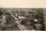
| This is an early view of the Delmar Loop taken looking east from the top floor of the Woman's Magazine Building in September, 1907. Delmar Garden Amusement Park is on the left, and a streetcar is just making the "loop" through the southwest corner of the Park to return to St. Louis. The Park Hotel is on the upper right, with Parkview Subdivision just beyond. |
| Acquisition of property for what would become Parkview began as early as 1901 by the Parkview Realty and Development Company. Beredith Realty Company was the developer, and the area was often referred to as the Beredith Tract. The Parkview plat was filed in 1905. This photograph was taken looking north from Washington University about 1908. The track and a train for the Chicago, Rock Island, Pacific Rail Road are in the foreground. Berlin Avenue (renamed Pershing Avenue) is the first street beyond the rail road tracks, then Waterman Avenue, both intersecting with Westgate Avenue. The back of the Park Hotel appears at left center, and buildings for the Delmar Race Track north of Delmar Boulevard are at right center. The two houses on the right are on Washington Avenue. |
| Acquisition of property for what would become Parkview began as early as 1901 by the Parkview Realty and Development Company. Beredith Realty Company was the developer, and the area was often referred to as the Beredith Tract. The Parkview plat was filed in 1905. This photograph was taken looking south toward Washington University about 1906 or 1907. The angle of the photograph is misleading and Parkview actually covers the full width of the photograph. The Kirkwood-Ferguson Streetcar track ran north and south just west of Parkview. |
| Acquisition of property for what would become Parkview began as early as 1901 by the Parkview Realty and Development Company. Beredith Realty Company was the developer, and the area was often referred to as the Beredith Tract. The Parkview plat was filed in 1905. In this photograph, taken in 1907, Westgate Avenue is in the foreground. The cluster of houses on the right is on Waterman Avenue. The cluster in the center is on McPherson. The building on the far left is an apartment building east of Skinker Road. |
| Acquisition of property for what would become Parkview began as early as 1901 by the Parkview Realty and Development Company. Beredith Realty Company was the developer, and the area was often referred to as the Beredith Tract. The Parkview plat was filed in 1905. This photograph was taken looking southwest from Skinker Road. The houses are all in the 6200 block of Waterman Avenue. Washington University's campus and Brookings Hall are visible in the distance. |
| Acquisition of property for what would become Parkview began as early as 1901 by the Parkview Realty and Development Company. Beredith Realty Company was the developer, and the area was often referred to as the Beredith Tract. The Parkview plat was filed in 1905. In this photograph taken looking east from the Park Hotel in 1906 two houses are under construction on Washington Avenue. In the foreground, west of Westgate Avenue, is the Parkview nursery where trees and plants were raised for use throughout the subdivision. |
| Acquisition of property for what would become Parkview began as early as 1901 by the Parkview Realty and Development Company. Beredith Realty Company was the developer, and the area was often referred to as the Beredith Tract. The Parkview plat was filed in 1905. This photograph was taken looking east from the Park Hotel in late 1907 or early 1908. Westgate Avenue is in the foreground. Washington Avenue is on the left and Westminster Avenue is on the right. Several houses have been completed on both streets. |
| Acquisition of property for what would become Parkview began as early as 1901 by the Parkview Realty and Development Company. Beredith Realty Company was the developer, and the area was often referred to as the Beredith Tract. The Parkview plat was filed in 1905. This photograph is part of a three-photo panorama taken from Washington University. The Chicago, Rock Island, Pacific Rail Road tracks and a train are in the foreground, paralleling Berlin Avenue (renamed Pershing Avenue). Diagonally on the right is Skinker Road. Most of the houses that appear in this photograph are east of Skinker Road. Only a few on the left are in Parkview. |
| Acquisition of property for what would become Parkview began as early as 1901 by the Parkview Realty and Development Company. Beredith Realty Company was the developer, and the area was often referred to as the Beredith Tract. The Parkview plat was filed in 1905. This photograph was taken in the spring of 1907, and the first group of houses in the 6200 block of Waterman had been built. The street in the foreground is Berlin Avenue (renamed Pershing Avenue). The Woman's Magazine Building is just visible between the first and second houses on the left. |
| Acquisition of property for what would become Parkview began as early as 1901 by the Parkview Realty and Development Company. Beredith Realty Company was the developer, and the area was often referred to as the Beredith Tract. This photograph was taken about 1907, looking northwest across the west end of Parkview toward Delmar. Edward Gardner Lewis' monumental Woman's Magazine Building and Woman's National Daily Building are visible in the distance, and the Park Hotel is on the right. Berlin Avenue (renamed Pershing Avenue) and Waterman Avenue intersect Westgate Avenue. The Chicago, Rock Island, Pacific Rail Road track and a train are in the foreground. |
| Acquisition of property for what would become Parkview began as early as 1901 by the Parkview Realty and Development Company. Beredith Realty Company was the developer, and the area was often referred to as the Beredith Tract. This photograph was taken looking northeast across the Chicago, Rock Island Pacific railroad tracks south of Parkview. Berlin Avenue (renamed Pershing Avenue) parallels the tracks. The nearest houses are in the 6200 block of Waterman Avenue. The largest single house on the left is on McPherson Avenue. |
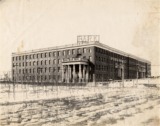
| The Epworth League built the Hotel Epworth to house visitors to the St. Louis World's Fair in 1904. After the World's Fair, it was renamed the Park Hotel, and became a popular residential hotel. This photograph shows the east facade of the building. The dense group of saplings in the foreground is actually the nursery for Parkview Subdivision, just to the east, where trees and bushes were grown to be transplanted to the park areas in Parkview. This photograph appeared in "The American Woman's League and University City," published in February 1908. |
Home | Search Photographs | Browse Photographs | Search Documents | Browse Documents | About | Links
All content ©2002 - 2014 University City Public Library. All rights reserved.
![]()