


| Your search for " Westgate Avenue (University City, Mo.) " returned 7 records . Click the thumbnail for the full record. | |
| Acquisition of property for what would become Parkview began as early as 1901 by the Parkview Realty and Development Company. Beredith Realty Company was the developer, and the area was often referred to as the Beredith Tract. The Parkview plat was filed in 1905. This photograph was taken looking north from Washington University about 1908. The track and a train for the Chicago, Rock Island, Pacific Rail Road are in the foreground. Berlin Avenue (renamed Pershing Avenue) is the first street beyond the rail road tracks, then Waterman Avenue, both intersecting with Westgate Avenue. The back of the Park Hotel appears at left center, and buildings for the Delmar Race Track north of Delmar Boulevard are at right center. The two houses on the right are on Washington Avenue. |
| Acquisition of property for what would become Parkview began as early as 1901 by the Parkview Realty and Development Company. Beredith Realty Company was the developer, and the area was often referred to as the Beredith Tract. The Parkview plat was filed in 1905. This photograph was taken looking south toward Washington University about 1906 or 1907. The angle of the photograph is misleading and Parkview actually covers the full width of the photograph. The Kirkwood-Ferguson Streetcar track ran north and south just west of Parkview. |
| Acquisition of property for what would become Parkview began as early as 1901 by the Parkview Realty and Development Company. Beredith Realty Company was the developer, and the area was often referred to as the Beredith Tract. The Parkview plat was filed in 1905. In this photograph, taken in 1907, Westgate Avenue is in the foreground. The cluster of houses on the right is on Waterman Avenue. The cluster in the center is on McPherson. The building on the far left is an apartment building east of Skinker Road. |
| Acquisition of property for what would become Parkview began as early as 1901 by the Parkview Realty and Development Company. Beredith Realty Company was the developer, and the area was often referred to as the Beredith Tract. The Parkview plat was filed in 1905. In this photograph taken looking east from the Park Hotel in 1906 two houses are under construction on Washington Avenue. In the foreground, west of Westgate Avenue, is the Parkview nursery where trees and plants were raised for use throughout the subdivision. |
| Acquisition of property for what would become Parkview began as early as 1901 by the Parkview Realty and Development Company. Beredith Realty Company was the developer, and the area was often referred to as the Beredith Tract. The Parkview plat was filed in 1905. This photograph was taken looking east from the Park Hotel in late 1907 or early 1908. Westgate Avenue is in the foreground. Washington Avenue is on the left and Westminster Avenue is on the right. Several houses have been completed on both streets. |
| Acquisition of property for what would become Parkview began as early as 1901 by the Parkview Realty and Development Company. Beredith Realty Company was the developer, and the area was often referred to as the Beredith Tract. This photograph was taken about 1907, looking northwest across the west end of Parkview toward Delmar. Edward Gardner Lewis' monumental Woman's Magazine Building and Woman's National Daily Building are visible in the distance, and the Park Hotel is on the right. Berlin Avenue (renamed Pershing Avenue) and Waterman Avenue intersect Westgate Avenue. The Chicago, Rock Island, Pacific Rail Road track and a train are in the foreground. |
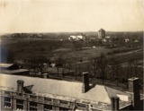
| This photograph was taken about 1907 from the Washington University campus, looking northwest toward Edward Gardner Lewis' monumental Woman's Magazine Building and Woman's National Daily Building. To the left is University Heights #1, Lewis' residence park. On the lower right is the southwest corner of Parkview, showing the intersection of Westgate and Berlin Avenues. The Kirkwood-Ferguson Streetcar tracks follow the western edge of Parkview, while the Chicago, Rock Island, Pacific Rail Road tracks are to the south. |
Home | Search Photographs | Browse Photographs | Search Documents | Browse Documents | About | Links
All content ©2002 - 2014 University City Public Library. All rights reserved.
![]()